Our Projects
Cost is ultimately the driver of economic success. This is why PAM focuses on projects which are located in competitive cost environments and preferably near relevant industrial clusters.
Rosario Copper Project
Product: Copper | Mineral: Manto Style Cu/Ag | Option for 100%
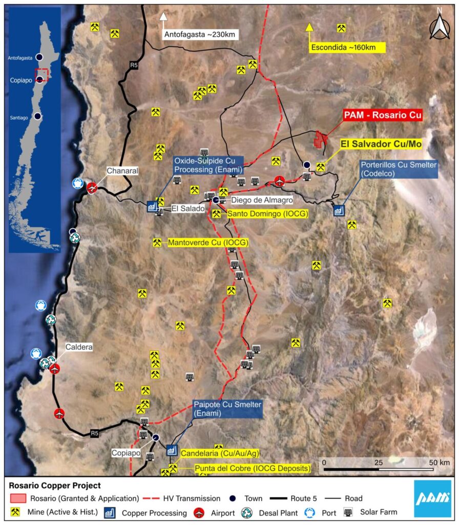
The Rosario Copper Project is one of the most strategically placed copper projects in South America, situated 10km to the north of Codelco’s El Salvadoe Copper Mine. The Project is interpreted as highly prospective yet significantly under explored Manto style copper-silver project.
1The Rosario Copper Project is one of the most strategically placed copper projects in South America, situated 10km to the north of Codelco’s El Salvadoe Copper Mine and 100km from Enami’s El Salado oxide and sulphide copper ore processing plant (actual road distance). Codelco’s Porterillos Copper Smelter is also located 40km south of the El Salvadore mine (actual road distance).
The Project is interpreted as highly prospective yet significantly under explored Manto style copper-silver project. This style of mineralisation occurs throughout the northern parts of Chile and is responsible for significant historical and current copper production. The largest examples of this deposit style have historic production and Mineral Resources of plus 200Mt at grades of 1% Cu or better along with by-product silver. These include the Mantos Blancos, El Solado and Michilla mines, along with a host of ‘smaller’ but significant deposits.
The project area has been subject to historic small scale mining and prospecting with numerous shallow pits and some underground workings. There is evidence of drilling having been undertaken on ground located south of the project area.
The only recorded exploration undertaken on the project area is rock chip geochemistry and mapping in several phases from 2012 to 2022. Rockchip samples were collected from small scale mine workings, prospecting pits and natural sub crop and outcrops. Sample types include semi-selective rockchips, random rockchips and some ‘channel’ chips, and are considered to be appropriate for the style of mineralisation present. Sample weights were generally in the 0.5-2kg range. Sample descriptions record the presence of copper oxide minerals at many locations in association with elevated copper grades reported.
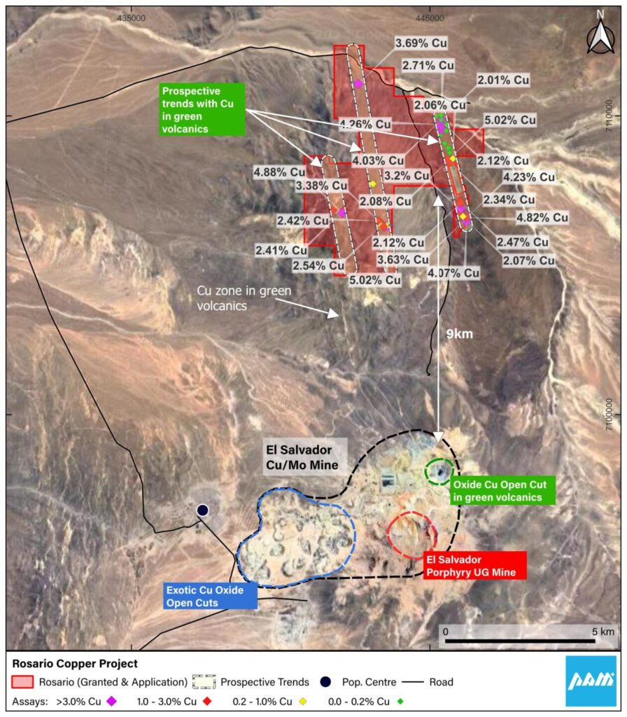
Results of 89 rock chip samples collected within the Project area returned 73 samples at >0.1% Cu giving an average copper grade of 2.13% ranging up to +5% Cu. Silver grades average 6g/t ranging up to 42g/t. Elevated gold grades of >0.10 ppm Au up to 0.32 ppm Au are reported in four samples only.
The Rosario Copper Project is interpreted as highly prospective yet significantly under explored Manto style copper-silver project. This style of mineralisation occurs throughout the northern parts of Chile and is responsible for significant historical and current copper production. The largest examples of this deposit style have historic production and Mineral Resources of plus 200Mt at grades of 1% Cu or better, along with by-product silver. These include the Chilean based Mantos Blancos, El Solado and Michilla mines, along with a host of ‘smaller’ but significant deposits in Chile.
The geology of the Project area is comprised of basic volcanics and volcano-sedimentary rocks deposited in a submarine setting during the early Cretaceous to early Tertiary. Mineralisation is hosted in the Mantos Greusos sequence consisting of andesitic volcanics and intercalated sandstones of late Cretaceous to Paleocene age. Several NWN trending faults with cross cutting WNW structures are present in the project area. These faults and structures have acted as hydrothermal fluid flow loci for the mineralisation, and deposited copper where physio-chemical conditions allow. Mineralised zones are interpreted to be from 20m wide along the NWN trending faults and potentially up to 200m wide along the cross-cutting WNW trending structures. Mineralised zones are associated with fractured and brecciated rocks, with carbonate-epidote and chlorite the common alteration products. Observed copper minerals at Rosario comprise copper oxides such as malachite and chrysocolla. At deeper levels, beneath the weathered zone copper sulphide minerals would be anticipated.
At Rosario, three distinct prospective NWN trends are evident. These have combined strike length of over 10km.
RK Lithium Project
Product: Lithium | Mineral: Lepidolite Pegmatite | Ownership: 100%
The RK Lithium Project is a high grade lepidolite pegmatite project situated in Southern Thailand, a low cost industrial economy which is home to SE Asia’s largest EV manufacturing hub.
The RK Lithium Project (‘RKLP’), inclusive of the RK Lithium Prospect (RK), the BT Lithium Prospect (RK), KT East Lithium Prospect (KT) and the KT West Lithium Prospect under application, is one of PAM’s key assets. RKLP is a hard rock lithium project with lithium hosted in lepidolite/muscovite rich pegmatites chiefly composed of quartz, feldspar, lepidolite and muscovite both lithium bearing micas, with minor cassiterite and tantalite as well as other accessory minerals. Previous open pit mining extracting tin from the weathered pegmatites was conducted into the early 1970’s.
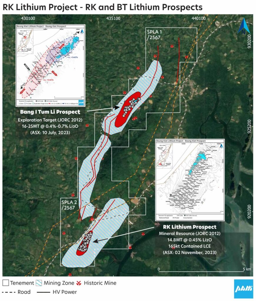
PAM has reported Mineral Resources and an Exploration Target at the RK and BT prospects respectively. Both the KT East and, upon grant, the KT West prospects represent potential extensions to the RK and BT Prospects, which, upon successful definition of a Mineral Resource and subsequent feasibility work, represent a potentially large addition to the Mineral Resources already defined at the RK Lithium Prospect and those expected from the BT Lithium Prospect Exploration Target. Work conducted so far at the KT East prospect indicates it has a footprint much larger than the RK and BT prospects.
The RK Lithium Project area was part of a major tin mining region up until the mid-1980s. Up to the late 1980 southern Thailand was a globally significant tin producer. In the Phang Nga Province from 1965 to 1990 recorded tin concentrate production was approximately 300,000 tonnes. Much of the tin production was derived from alluvial or offshore sources, however, there were some primary deposits being mined.
In the late 1960s a joint Thai/British Geological Survey study was undertaken in the region (Garson et al, 1969). It was during this study that the lithium-bearing mineral lepidolite was identified in weathered pegmatites that were being mined for tin at the Reung Kiet (RK) and Bang I Tum (BT) open pit mines as well as at other mines in close proximity. The 1960s study conducted geological mapping, geochemical analysis, and mineralogical descriptions of various tailings, concentrate, and rock samples as well as lepidolite beneficiation studies. The lepidolite was found to contain 3-4% Li2O. With a significant focus on two key tin mines, Reung Kiet (RK) and Bang I Tum (BT), the survey stated:
the pegmatites at Reung Kiet and Bang I Tum may well be the largest un-zoned lepidolite pegmatites yet recorded; and
lepidolite is fairly evenly distributed both along the length of the pegmatite and from wall to wall. In places there is local enrichment of massive lepidolite
Until PAM’s exploration programs began there had been little recorded exploration activity in the project area since the 1960’s study.
The RK Lithium Project comprises RK Lithium Prospect (RK), the BT Lithium Prospect (RK), KT East Lithium Prospect (KT) and the KT West Lithium Prospect under application:
The RK Lithium Prospect (RK)
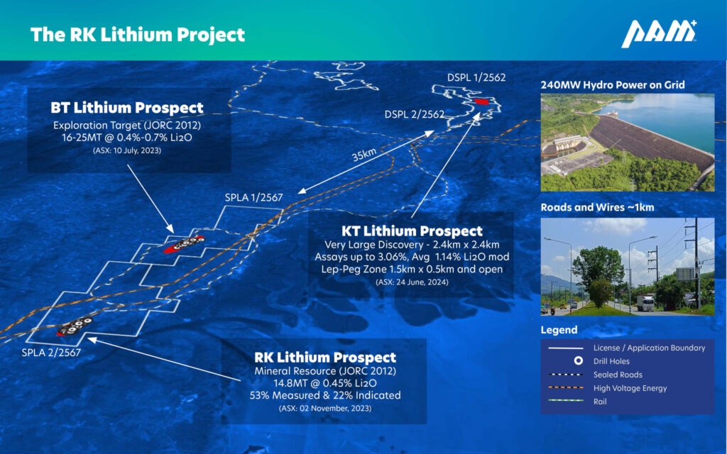
The RK Lithium Prospect (RK) is located about 8km south of the BT Lithium Prospect (BT) in southern Thailand. At RK PAM has estimated a Mineral Resource Estimate of 14.8 million tonnes at a grade 0.45% Li2O, containing 164,500 tonnes LCE. See PAM’s ASX announcement “Reung Kiet Lithium Project Mineral Resource Update” dated 2 November, 2023.
The RK Prospect hosts a relatively large open cut tin mine that operated into the 1970’s. The old pit is about 500m long and up to 125m wide. Mining of weathered pegmatites was undertaken by open cut hydraulic methods to about 30m below surface and ceased when hard rock was intersected.
Pan Asia has identified a prospective zone over 1km long. Mineralisation remains open along strike to the north and south, with strong mineralisation particularly evident at surface and at depth in the south. PAM retains a 100% interest in RK.
The BT Lithium Prospect (BT)
The BT Lithium Prospect (BT) is located about 8km north of the RK in southern Thailand. At BT PAM has estimated a drill supported Exploration Target of 16 to 25 million tonnes at a grade ranging between 0.4% to 0.7% Li2O. See PAM’s ASX announcement “Reung Kiet Lithium Project Exploration Target Substantially Increased” dated 10 July, 2023.
The potential quantity and grade of the Exploration Target are conceptual in nature. There has been insufficient exploration to estimate a Mineral Resource and it is uncertain if further exploration will result in the estimation of a Mineral Resource.
The BT hosts a significant historic tin mine that extends for almost 2km along strike. Mining of weathered pegmatites was undertaken by open cut hydraulic methods to about 40m below surface and ceased when hard rock was intersected. PAM retains a 100% interest in BT.
The KT East Lithium Prospect (KT)
The KT East prospect is part of the RK Lithium Project and is situated approximately 35km north of the RK and BT prospects. PAM has reported Mineral Resources and an Exploration Target at the RK and BT prospects respectively.
Both the KT East and upon grant the KT West prospects represent potential extensions to the RK and BT Prospects, which, upon successful definition of a Mineral Resource and subsequent feasibility work, represent a potential extension to the resources already defined at the RK Lithium Prospect and those expected from the BT Lithium Prospect Exploration Target.
Tama Atacama Lithium Project
Product: Lithium | Mineral: Lithium Brines | Option for 100%
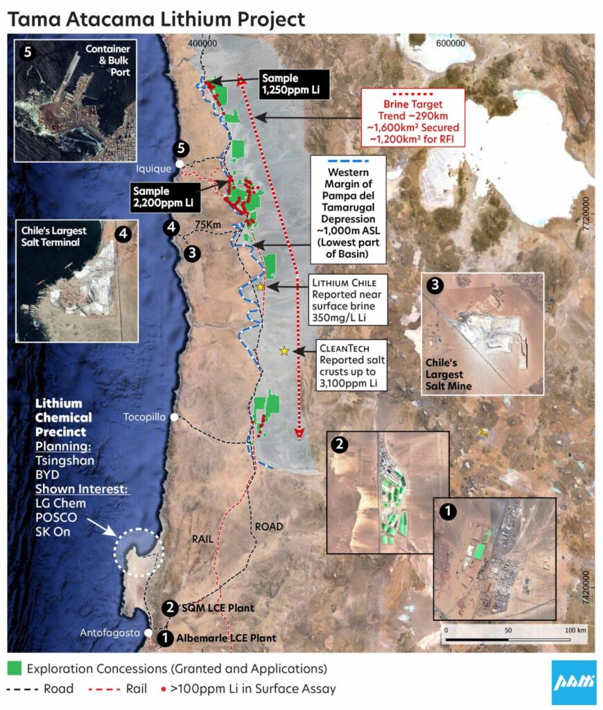
The Tama Atacama Lithium Project is one of the most strategically situated lithium brine projects in South America, located 75km from several major shipping ports and on rail to Antofagasta, the largest lithium processing hub in South America.
The Tama Atacama Lithium Project distinguishes itself as one of South America’s largest and most strategically positioned lithium brine projects with ~120,000ha (~1,200km2) of granted exploration licenses or exploration license applications over which PAM has entered into binding Option Agreements to Purchase 100% of the project area. See PAM’s ASX announcements titled “Tama Atacama Lithium Option Agreements Signed” and “Tama Atacama Lithium Presentation” dated 2nd January and 12th February, 2024 respectively.
The Tama-Atacama Lithium Project areas (Projects) are hosted within the Pampa del Tamarugal Basin (PT Basin), a 12,500km2 sedimentary basin located in the Atacama Desert in northern Chile. The Projects exhibit strong potential for deeper lithium brines and shallow lithium clays.
The PT Basin is a major paleo-basin developed during the last 25 million years, as a consequence to uplift of the Domeyko or Pre Cordillera (western Andes) to the east, and the Coastal Cordillera to the west, which acted as a natural barrier for drainage emanating from the western Andes whereby intermittent, but larger amounts of precipitation relative to present has bought water and sediments via several large river valleys and progressively filled the basin. Thick sedimentary, local volcanic, and evaporite sequences developed until the Loa and Camarones rivers were able to commence draining this large paleo lake in the south and north respectively.
Prior to this draining, the PT Basin was characterized by a huge ephemeral lagoon of ponded Andean drainage which carried large amounts of sediments in a fluvial to the lacustrine environment present in the basin. Over time, the generally high background levels of lithium and associated elements in the groundwater sediments became further enriched via episodic evaporation under increasingly arid conditions. There may also be a hydrothermal water/lithium input from lithium-rich fluids migrating up fault zones or migrating downstream from surficial hydrothermal discharges. This model is applicable to the younger salars higher in the Andes, such as Salar de Atacama, and reconnaissance work suggests similar geochemical signatures in the salars that form the northern portion of Tama Atacama.
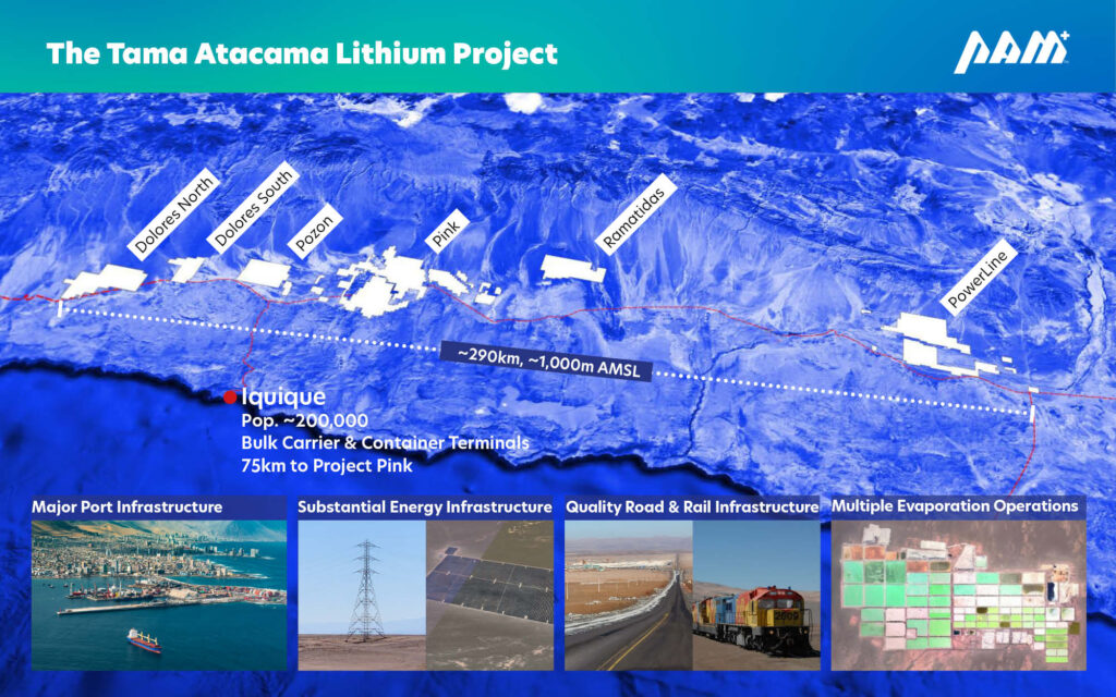
Tama Atacama consists of 6 highly prospective lithium prospects covering a total area of ~1,600km² and spanning over 290km from south to north.
The Project is situated at an altitude of 800-1100m, it is one of the lowest-lying lithium brine projects globally, and the project is set in a hyper-arid environment with very high evaporation rates, is well-supported with all necessary transport and energy infrastructure, and is situated 40-60km from the coast and only 75km from Iquique, a well-equipped coastal city with a population of 200,000, a deep water bulk and container port, and regular flights to Santiago. Tama Atacama is only 75km from Port of Patillos, Chile’s largest salt export terminal, providing PAM a potential solution for waste salt, and several pipelines pump sea water through PAM’s project areas, providing a potential solution to achieving water balance.
Certain areas of the Salars host historic borate, potassium, and salt extraction, with many areas immediately west of the Salar the host to historic nitrate mining. There is little record of any of these past mining activities. Records for previous exploration and mining are essentially non-existent as there was no requirement to lodge reports for exploration or mining activity in Chile at that time. In the 1960’s-70’s ENAP, the then National Petroleum Company, conducted oil and gas exploration in the PT Basin. Work included seismic surveying and drilling. Reported drilling results indicate basin sediments from around 300-700m thick with brines located within this horizon. There are some reports about shallow groundwater investigations, particularly in the north to eastern parts of Salar Pintados. These remain to be fully interpreted.
